


 Multi-language
 1 PC
1 PC Windows
 1-Year License


Autodesk ReCap Pro 2025 – Professional Reality Capture and 3D Scanning Software
Turn Real-World Data into Intelligent 3D Models with Autodesk ReCap Pro 2025
In architecture, engineering, and construction, accuracy is critical. Whether you’re planning a renovation, documenting an existing structure, or creating digital twins, Autodesk ReCap Pro 2025 gives you the tools to convert laser scans and photos into rich, detailed 3D models. With this latest version, Autodesk continues to push the boundaries of precision, automation, and integration in the world of reality capture.
At GraphicLicense, we offer genuine licenses for Autodesk ReCap Pro 2025, complete with instant digital delivery, Autodesk Account activation, and expert customer support. Use ReCap Pro 2025 to simplify your data capture workflows and create high-fidelity models you can trust throughout the project lifecycle.
What Is Autodesk ReCap Pro 2025?
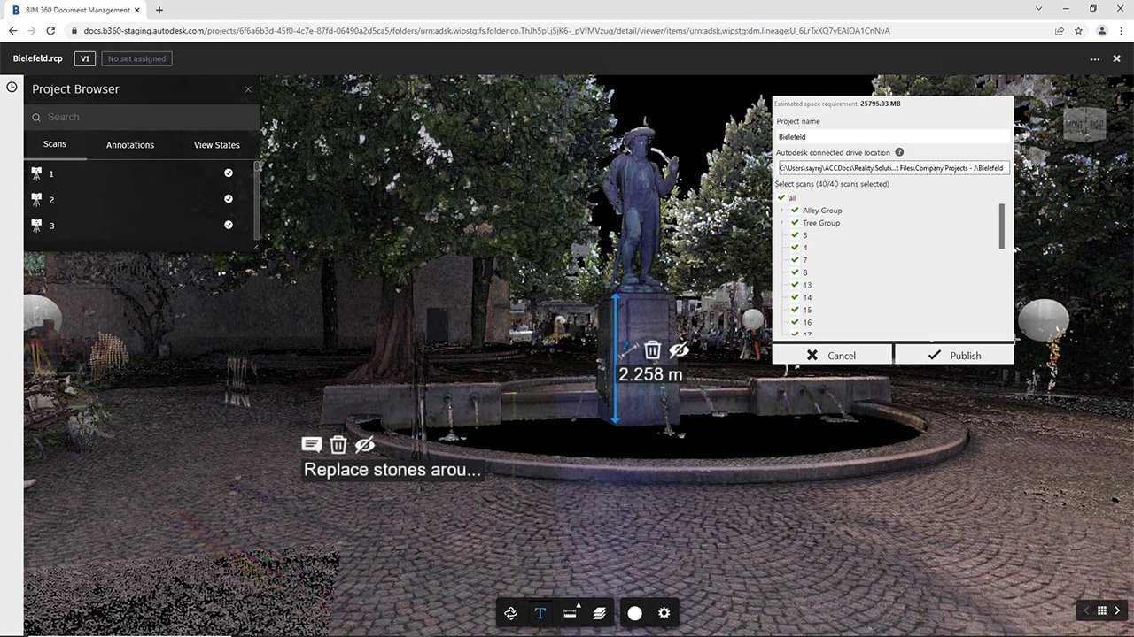
Autodesk ReCap Pro 2025 is advanced reality capture software that allows you to import, process, and edit 3D scan data from LiDAR, drones, laser scanners, and photogrammetry. ReCap Pro supports both terrestrial and aerial scanning inputs, giving professionals the ability to build highly accurate point clouds and 3D meshes of buildings, infrastructure, topography, or industrial environments.
ReCap stands for “Reality Capture.” The software enables surveyors, architects, engineers, and BIM professionals to digitally capture existing conditions with millimeter-level precision, enabling intelligent modeling and design validation in Autodesk platforms such as Revit, Civil 3D, and Navisworks.
What’s New in Autodesk ReCap Pro 2025?
The 2025 release of Autodesk ReCap Pro includes several performance, usability, and integration upgrades:
Improved scan alignment tools
ReCap Pro 2025 enhances automatic registration workflows with smarter point matching and fewer manual adjustments needed.
Faster project import and indexing
Large projects now load and process more efficiently, saving time during initial file handling.
Enhanced cloud integration
Workflows between ReCap Pro and Autodesk Docs or BIM 360 are now more seamless, allowing easier sharing and access to point cloud data in collaborative environments.
Refined mesh creation tools
Users can generate high-resolution meshes from scan or photogrammetry data more efficiently, with fewer artifacts and improved surface continuity.
More control over region segmentation
Better tools for managing scan regions, clipping boundaries, and cropping point clouds for use in downstream software.
These updates make Autodesk ReCap Pro 2025 the most efficient and reliable version yet for reality capture professionals.
Key Features of Autodesk ReCap Pro 2025
Reality Capture and 3D Scanning
ReCap Pro processes data from terrestrial laser scanners, drone-captured images, and mobile LiDAR units. You can work with millions or even billions of scan points to recreate highly detailed environments.
Laser Scan Processing
Import and register scans from hardware such as Leica, Faro, or Trimble. ReCap Pro automatically aligns and stitches scan data together, creating unified point clouds with minimal user input.
Photogrammetry
Use drone or aerial imagery to create 3D models and orthophotos. Upload image sets to Autodesk cloud services and generate accurate, georeferenced reconstructions of terrain, buildings, or assets.
Point Cloud Cleanup
ReCap Pro 2025 includes tools for removing noise, correcting misaligned points, cropping regions, and merging scans. You can also set scan region visibility to isolate specific areas for export or modeling.
Advanced Registration
Use automatic and manual tools to register multiple scans into a single coordinate system. Support for target-based registration is included for higher accuracy in professional survey work.
Annotation and Markups
Add tags, notes, and images directly to the 3D scan to document site conditions, mark issues, or share information with team members. This improves communication between field and office teams.
Mesh Reconstruction
Convert point clouds into high-resolution 3D meshes, suitable for visualization, simulation, or modeling. This is especially useful for reverse engineering and historical preservation projects.
Coordinate System Support
ReCap Pro supports global and local coordinate systems, ensuring compatibility with GIS and civil engineering workflows. You can georeference your scans or align them with design models from Revit or Civil 3D.
Seamless Integration with Autodesk Products
Export your scan data to Autodesk Revit, AutoCAD, InfraWorks, Navisworks, and Civil 3D. ReCap Pro serves as the starting point for many BIM and digital twin workflows, making it a critical part of the Autodesk ecosystem.
Autodesk Drive and BIM 360 Integration
Upload and share projects directly to the cloud using Autodesk Docs, Drive, or BIM 360. This makes it easy for teams to collaborate remotely while maintaining version control and data security.
Who Should Use Autodesk ReCap Pro 2025?
ReCap Pro is built for professionals in a variety of industries where real-world accuracy is essential:
-
Architects and BIM managers capturing as-built conditions
-
Civil engineers and surveyors documenting terrain and infrastructure
-
Construction managers performing quality verification and clash detection
-
Facility managers and owners creating digital twins
-
Industrial designers scanning mechanical environments for retrofit
-
Heritage preservation specialists creating digital records of historic sites
-
Drone operators and photogrammetry professionals conducting aerial surveys
If your workflow begins with real-world measurement, Autodesk ReCap Pro 2025 gives you the tools to make your capture process smarter, faster, and more accurate.
Benefits of Using Autodesk ReCap Pro 2025
High Accuracy with Minimal Manual Effort
ReCap Pro automates much of the registration and alignment process, helping you produce highly accurate models without spending hours on manual editing.
Time and Cost Savings on Site Work
Minimize the number of site visits by capturing everything once. Use point clouds for measurement, documentation, and validation at every stage of the project.
Improved Collaboration
Share scan data with design teams, construction stakeholders, or clients. Everyone works from the same reality-based model, reducing miscommunication and errors.
Reduced Risk of Rework
With accurate 3D models from day one, teams can make better-informed decisions and avoid clashes or measurement errors later in the workflow.
Supports BIM and Digital Twin Workflows
Integrate captured data directly into Autodesk design and analysis tools to enable BIM coordination, facility lifecycle management, and simulation-based planning.
File Format and Device Compatibility
ReCap Pro 2025 supports a wide range of industry-standard file formats and hardware devices:
Supported Input Devices
Leica, Faro, Trimble, Topcon, and other laser scanners
DJI and other drone systems for photogrammetry
Mobile mapping and handheld LiDAR systems
Supported File Formats
RCP, RCS (ReCap native)
E57, LAS, LAZ
PTX, PTS
JPG, PNG for photogrammetry
OBJ and FBX for mesh export
Autodesk cloud upload formats
System Requirements for Autodesk ReCap Pro 2025
For best performance, your workstation should meet or exceed the following:
Operating System: Windows 10 or 11 (64-bit)
Processor: 3.0 GHz or faster multi-core processor
Memory: 32 GB RAM recommended for large datasets
Graphics: Dedicated GPU with DirectX 11 or later
Disk Space: SSD with at least 50 GB free space
Internet Connection: Required for cloud services and photogrammetry processing
Licensing and Delivery
When you purchase Autodesk ReCap Pro 2025 from GraphicLicense, you receive:
-
A genuine Autodesk license linked to your Autodesk account
-
Instant digital delivery and activation instructions
-
Access to official Autodesk downloads and updates
-
Full support for installation, configuration, and license management
-
Flexible subscription options (annual, multi-year, or enterprise-level)
-
Business documentation and invoicing for procurement departments
All licenses are suitable for commercial use and fully eligible for Autodesk technical support.
Why Buy Autodesk ReCap Pro 2025 from GraphicLicense?
Verified Licensing
We only sell authentic Autodesk products, ensuring compliance and support eligibility.
Fast, Secure Delivery
Receive your license key and activation details via email shortly after purchase.
Competitive Pricing
We offer special rates for teams, multi-year subscriptions, and repeat customers.
Expert Support
Our team understands real-world workflows in construction, surveying, and engineering. We assist with setup, data import, and integration with other Autodesk tools.
Business-Ready Services
Need a formal quote, invoice, or procurement support? We deliver full documentation and VAT-compliant billing upon request.
How to Get Started
-
Choose your Autodesk ReCap Pro 2025 subscription plan on GraphicLicense
-
Complete your secure checkout
-
Receive your license and activation details by email
-
Log into your Autodesk Account and download ReCap Pro 2025
-
Install, activate, and begin capturing the real world in digital form
Our support team is ready to assist with setup, system requirements, and cloud integration.
Conclusion
Autodesk ReCap Pro 2025 is the industry-leading solution for reality capture professionals who need precise, efficient, and flexible tools for 3D scanning, point cloud processing, and photogrammetry. Whether you are capturing existing site conditions, validating construction progress, or preparing scan data for BIM, ReCap Pro helps you get the job done faster and with greater accuracy.
Buy your Autodesk ReCap Pro 2025 subscription from GraphicLicense today and take control of your digital capture workflow with software trusted by architects, engineers, and surveyors worldwide.


There are no reviews yet.