

 Multi-language
 1 PC
1 PC Windows
 1-Year License


Autodesk InfraWorks 2025 – Infrastructure Design and Conceptual Planning Software
Visualize, Plan, and Design with Confidence Using Autodesk InfraWorks 2025
Infrastructure planning and design require more than traditional CAD. Today’s transportation, land development, and utility projects demand tools that integrate real-world context, data-driven insights, and collaborative workflows. Autodesk InfraWorks 2025 is the solution that brings it all together. It enables engineers, urban planners, and civil designers to rapidly build and evaluate infrastructure designs in a 3D real-world environment.
At GraphicLicense, we offer authentic Autodesk InfraWorks 2025 licenses with secure delivery, Autodesk account activation, and expert customer support. Whether you’re conceptualizing a new highway interchange or visualizing a land development project, InfraWorks helps you explore more design options, communicate ideas clearly, and make smarter decisions early in the project lifecycle.
What Is Autodesk InfraWorks 2025?
Autodesk InfraWorks 2025 is advanced infrastructure modeling software that enables conceptual design in the context of the real world. It integrates GIS, CAD, BIM, and point cloud data into one platform, allowing users to model roads, bridges, drainage systems, railways, and site developments in 3D.
Unlike traditional civil design tools, InfraWorks focuses on early-stage planning, design visualization, and stakeholder communication. It helps users create compelling models with real-world terrain, aerial imagery, and existing infrastructure data to support more informed decision-making before final design begins.
InfraWorks is a vital tool for professionals working in urban design, transportation engineering, water infrastructure, and land development.
What’s New in Autodesk InfraWorks 2025?
Autodesk InfraWorks 2025 brings improved performance, better integration with Civil 3D and Revit, and enhanced visualization capabilities. Key updates include:
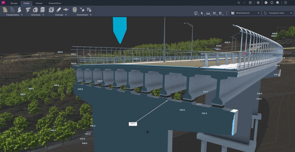
Enhanced Bridge Modeling Workflows
New tools make it easier to define piers, bearings, and girder assemblies with higher precision. Users can now generate more accurate bridge analysis data for integration with Autodesk Structural Bridge Design and Revit.
Improved Interoperability with Civil 3D
Roadway and grading models in InfraWorks now export more cleanly into Civil 3D, preserving design intent and terrain surfaces for detailed engineering.
Contextual Modeling with Better Terrain Tools
InfraWorks 2025 includes refined surface editing tools for more accurate ground modeling and slope grading, especially in complex terrain or urban environments.
Faster Model Regeneration and Performance
Larger models regenerate more quickly thanks to optimized data handling and improved rendering speeds, particularly when working with point clouds and GIS layers.
Support for Updated Revit and IFC Standards
Improved support for updated Revit file versions and IFC 4.3 ensures that infrastructure data can flow smoothly across multidisciplinary teams.
Key Features of Autodesk InfraWorks 2025
Real-World Context Modeling
Autodesk InfraWorks enables users to import GIS, satellite imagery, terrain data, city maps, and point clouds to build 3D models that reflect actual site conditions. These context models provide a realistic foundation for infrastructure design and help teams plan with confidence.
Roadway and Transportation Design
Use InfraWorks to lay out and analyze roads, intersections, and roundabouts. Create complex alignments, design profiles, and traffic simulations. InfraWorks supports parametric road modeling and preliminary design tools that accelerate early planning.
Bridge Design
Design bridges in context with roads, rivers, terrain, and existing infrastructure. InfraWorks includes component-based bridge modeling tools that help define decks, piers, bearings, abutments, and superstructure elements. Integrated analysis helps validate geometry before transferring to structural design platforms.
Watershed and Drainage Modeling
Model water flow, terrain grading, and runoff with watershed analysis tools. Use this data to inform decisions about stormwater design, site grading, and sustainability.
Rail and Transit Design
InfraWorks includes tools for rail and light rail transit planning. Users can model tracks, stations, and embankments with real-world topography and assess impacts early in the design phase.
Site and Land Development Planning
Quickly model grading plans, site boundaries, and infrastructure layouts for new developments. Combine this with visual context to create presentation-ready concepts for stakeholders and clients.
Collaboration with Civil 3D, Revit, and BIM 360
InfraWorks integrates with Autodesk Civil 3D for detailed engineering design and with Revit for bridge and tunnel structures. Share models and data with Autodesk Docs or BIM 360 for cloud collaboration with project teams.
Visual Storytelling and Presentation Tools
Use InfraWorks to create high-quality renderings, videos, and animations that show how a project will look in its real-world environment. These tools are useful for public engagement, permitting, and funding presentations.
Benefits of Using Autodesk InfraWorks 2025
Accelerate Decision-Making
With InfraWorks, stakeholders can evaluate different design scenarios quickly, without waiting for fully detailed CAD models. This speeds up approvals and reduces costly design changes later.
Better Communication Across Teams
InfraWorks models are visually rich and easy to understand. They help bridge the gap between technical and non-technical audiences, supporting clearer communication between engineers, clients, city officials, and the public.
More Design Options in Less Time
InfraWorks empowers users to explore multiple alternatives during early planning. Test different routes, alignments, or structures within the same environment and select the most efficient and cost-effective design.
Early Clash Detection and Risk Reduction
By modeling in the context of real-world terrain and infrastructure, users can spot potential design conflicts or environmental impacts early in the project—before they become costly construction issues.
Seamless Integration with BIM Workflows
InfraWorks is part of the Autodesk AEC Collection and integrates with Civil 3D, Revit, Navisworks, and AutoCAD. This makes it easy to move from conceptual design to detailed engineering with no data loss.
Who Should Use Autodesk InfraWorks 2025?
InfraWorks is purpose-built for professionals in infrastructure planning, civil engineering, and urban development. It is ideal for:
-
Transportation engineers
-
Civil infrastructure designers
-
Urban planners
-
Land developers
-
Landscape architects
-
Stormwater and drainage engineers
-
Government agencies and municipalities
-
Surveying and GIS professionals
If your work involves planning or visualizing civil infrastructure in real-world conditions, Autodesk InfraWorks 2025 will enhance your productivity and decision-making.
Supported File Types and Data Integration
Autodesk InfraWorks 2025 supports a wide range of data sources and formats, including:
-
GIS formats: SHP, GDB, WFS, and raster imagery
-
CAD formats: DWG, DXF, DGN
-
BIM: RVT, IFC 4.3, IMX
-
Terrain and point clouds: DEM, LAS, E57, XYZ
-
Model exchange: FBX, OBJ, SketchUp (SKP)
-
Civil design data: Civil 3D corridors and surfaces
These capabilities allow you to build highly detailed, data-rich models from multiple disciplines and sources.
System Requirements
To run Autodesk InfraWorks 2025 effectively, your system should meet the following minimum specifications:
Operating System: Windows 10 or 11 (64-bit)
CPU: Quad-core Intel or AMD processor, 3.0 GHz or faster
RAM: 16 GB minimum (32 GB recommended for large models)
Graphics: Dedicated GPU with 4 GB memory or more (DirectX 12 support)
Storage: SSD with at least 100 GB free space
Internet Connection: Required for cloud services and model syncing
InfraWorks benefits from high-performance workstations, especially for large-scale projects involving LiDAR or complex terrain.
Licensing and Delivery
At GraphicLicense, we provide 100 percent genuine Autodesk InfraWorks 2025 licenses with:
-
Instant digital delivery
-
Autodesk Account activation
-
Access to official updates and cloud tools
-
Annual or multi-year subscription options
-
Business invoicing and licensing documentation
-
Commercial-use eligibility with expert support
Licenses are linked to your Autodesk ID and managed through Autodesk’s secure cloud infrastructure.
Why Buy Autodesk InfraWorks 2025 from GraphicLicense?
Authentic Autodesk Licensing
We are a trusted software reseller offering verified Autodesk products with full access to technical support and cloud services.
Fast Delivery and Activation
Receive your license and installation instructions quickly via email, usually within hours of purchase.
Competitive Pricing
Save on your subscription with discounts for multi-year plans and team licenses.
Professional Support
Our support team understands AEC workflows and can help with setup, compatibility, and integration questions.
Business-Ready Services
We provide VAT-compliant invoices, quotes, and documentation for enterprise and public-sector procurement.
How to Get Started with Autodesk InfraWorks 2025
-
Choose your preferred Autodesk InfraWorks 2025 subscription on GraphicLicense
-
Complete your secure checkout
-
Receive your license key and activation details by email
-
Log in to your Autodesk Account and download InfraWorks 2025
-
Install, activate, and begin modeling real-world infrastructure
If you have questions about system requirements or setup, our technical team is ready to assist.
Conclusion
Autodesk InfraWorks 2025 is the essential tool for conceptual infrastructure design. With powerful modeling, visualization, and analysis tools, it empowers engineers, planners, and designers to make faster, more informed decisions during the early stages of civil infrastructure projects.
Whether you’re designing a new transportation corridor, evaluating a stormwater system, or presenting a site development plan, InfraWorks helps you visualize and refine your ideas in context. It improves collaboration, reduces design risk, and sets the stage for successful project delivery.
Purchase your Autodesk InfraWorks 2025 subscription from GraphicLicense and take your infrastructure planning to the next level.


There are no reviews yet.